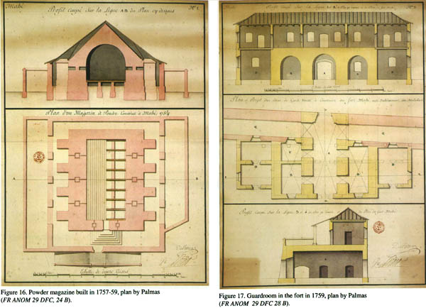


Old Mahe (1721-1817) According to Eighteenth Century French Plans
Book Specification
| Item Code: | NAL452 |
| Author: | Jean Deloche |
| Publisher: | Institut Francais De Pondichery |
| Language: | English |
| Edition: | 2013 |
| ISBN: | 9788184701937 |
| Pages: | 43 (Throughout Color Illustrations) |
| Cover: | Paperback |
| Other Details | 8.5 inch x 11.0 inch |
| Weight | 200 gm |
Book Description
Mahe territory surrounded on all sides by Kerala is officially a part of the Union Territory of Puducherry. Situated at a distance of 6 km south-east of Thalassery, it is today an attractive little town densely covered with coconut trees. When it was a French settlement in the 18th century, it represented for a time a place of considerable importance and trade, but having fallen thrice into the hands of the British, the settlement suffered immensely before it was returned to France as a small colony, an enclave within British India.
There is no comprehensive history of this trading post. Fortunately the unique collection of maps plans preserved in French Archives allows us to present a full picture of the urban development of the town from the date of settlement to the restoration of territory. These different plans are invaluable: they show the topographical substratum and the natural features of the surroundings, and give us much new information on the old settlement which is not found in French and English literary sources.
Mahe territory (town and villages), surrounded on all sides by Kerala (Figs 1 & 2), is officially a part of the Union Territory of Puducherry. Situated at a distance of 6 km south-east of Thalassery, the attractive little town of Mahe lies on a river estuary, with some picturesque small hills. There is a spacious harbour and a rocky bar, and the town is densely covered with coconut trees.
When it was a French settlement in the 18th century, it represented for a time a place of considerable importance and trade but it fell three times into the hands of the British, and the settlement suffered immensely before it was returned to France as a small colony, an enclave within British India. There is no comprehensive history of this trading post.
In 1917, A. Martineau published his famous monograph on Les origines de Mahe de Malabar covering the period 1720-1738. In 1934, 1936, E. Gaudart brought out the Catalogue des manuscrits des anciennes archives de l’ Inde francaise, which concern the Mahe settlement from 1739 to 1808 and from 1816 to 1855.
Since then, no new investigations have been carried out regarding the crucial periods of the old town development. As the unique collection of maps and plans preserved in French Archives is available for consultation on CD or via the Internet, it is now possible to present a full picture of the urban development of the town from 1721to 1817, i.e. from the date of settlement to the restoration of territory at the beginning of the 19th century.
These different plans, showing the topographical substratum and the natural features of the surroundings, give us much new information on the old settlement which is not found in French and English literary sources, are invaluable.
Most of the plans appear to have been made with care and relative accuracy, but, if we want to make a rigorous study of the old town, we have to locate them on a modern plan and produce a scientific representation of the different elements found in them.
As all the constructions of Mahe, civil and military, were destroyed by the British, the ancient toponymy has been partly forgotten and it is difficult to locate the various constructions of Old Mahe. We therefore need reliable landmarks in order to superimpose the old plans on modern ones.
That said, we have identified some of the distinguishing landscape features:
-to the north of the river, between the Little and Great Kallayi hills (petit and Grand Calay), Fort Saint-Georges was located on an elevation called at that time Montagne verte and today Georges kunnu;
-to the south of the river, the main landmark is the new Sainte-Therese d’ Avila church, built on the site of the old structure, and, close to this building, the area called Maliyamel Paramba, also known as La colonie or Ancien gouvernement, which corresponds to the Hotel de la direction, the Government house;
-to the east of the settlement, Fort Conde and Fort Dauphin crowned the two hills of Korakuruppaludekkunnu (Caragouroup), on the site of the present Hindu cremation ground and Tamantakkunnu (Tamantacounou), today called Aspatrikkunnu, situated on the site of the present Government hospital;
-the Rock Battery (Batterie des roches) was built on a rocky outcrop overlooking the coastal area today known as Parakkal, the exact location of which could not be ascertained, since the place is densely populated: these defence works-the Fort Conde, Fort Dauphin and the Rock Battery-marked
| Introduction | 1 | |
| I | Early Stages (1720-1728) | 5 |
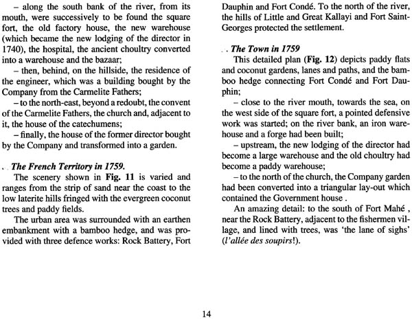
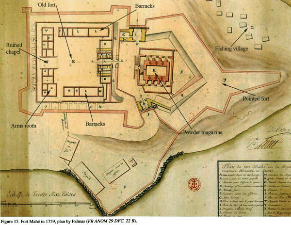
| II | Mahe (1728-1761): Urban Expansion and Defensive Works | 13 |
| III | Mahe (1728-1761): Urban Expansion and Major Constructions | 19 |
| IV | Mahe (1761-1778): Decline and Reconstruction of the Town | 24 |
| V | Mahe (1778-1817): Decay and Misery | 32 |
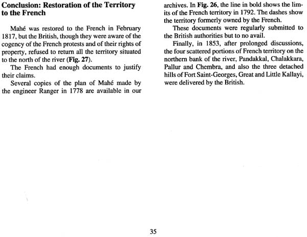
| Conclusion: Restoration of the Territory to the French | 35 | |
| Bibliography | 38 | |
| Illustrations | 39 |