

Mandu
Book Specification
| Item Code: | NAR322 |
| Author: | D. R. Patil |
| Publisher: | ARCHAEOLOGICAL SURVEY OF INDIA |
| Language: | English |
| Edition: | 2004 |
| Pages: | 68 |
| Cover: | PAPERBACK |
| Other Details | 9.00 X 5.50 inch |
| Weight | 130 gm |
Book Description
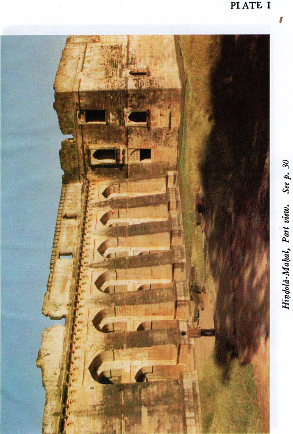
The Hill-Fort of Mandu (22° 2' N and 75° 26' E) is situated about 35 kilometres south of Dhar, headquarter of the District of that name in Madhya Pradesh. The hill rises 633.7 m above the sea-level and is separated from the main plateau of Malwa by a deep ravine, called the Kakra Khoh, which encircles it on its west, north and east and finally vanishes into the Nimar plain in the south. It is irregular in shape, with prominently higher spur of Songadh projecting into the west and a narrow but deep 'chasm of the ravine, penetrating right into the heart of the hill, to its east. Its length, east-to-west, is about 6 to 8 kilometres, whilst its width, north-to-south, is between 5 to 6 kilometres.
The hill range is endowed with a very attractive natural scenery, which is at its best during the rainy season, when on all sides, it is clothed in green with a number of brooks and torrents, rushing down into the ravine winding about its sides below. The vegetation is at its best and most luxurious in the monsoons, the beauty of which is further enhanced by about a dozen lakes and ponds interspersed on its top. The hill may, therefore, very well be styled as the beauty spot of Malwa and this is probably the reason why the city, enclosed within its fort-walls, when in its prime, was called by the Muslim rulers as Shadiabad, 'the City of Joy'. Indeed, to an emperor with aesthetic sense, like Jahangir, there was 'no place so pleasant in climate and so pretty in scenery as Mandu in the rainy season.'
The most convenient rail-heads for Mandu are Mhow and Indore from where it is connected by good roads, via Dhar, the distance being 92 kilometres from Mhow and 98 kilometres from Indore.
IT WAS IN THE MIDST OF AN INVITING NATURE THAT sometime early in the sixth century A D history was first made here and some sort of fortification was attempted by the political power of the day. A Sanskrit inscription, dated Vikrama Sarhvat 612 (A D 555), on the pedestal of a Jaina image of Adinatha found at Talanpur, near Kukshi in District Dhar, says that the image was installed in a temple of Pativanatha, in a locality called Tarapura inside Mandapa-Durga, by a merchant named Chandrasirhha Sha.1 Firishta, the celebrated Muhammadan historian, quotes a legend saying that in the days of Khusrau Parviz (A D 590-628) the fort was built by `Anand Deo Rajput of the tribe of Bies', a name which is not traceable amongst the historical personalities of the day so far known to us. The above inscrip-tion, however, leaves no doubt about the existence of the hill-fort under the name of Mariclapa-Durga in the middle of the sixth century. It must have been built some time before A D 555. About the origin of the Sanskrit name Maridapa-Durga there is no clue available at present. Its Prakrit or vernacular equivalent is `Mandava', a name by which it is still popularly called in the region. The word Maridava has been further corrupted to the present name of Mandu. Ma ,ndava is found so mentioned also in Persian histories of the medieval period.
During the next three centuries we hear nothing about the fort. It seems, in the tenth century, that the fort formed part, probably as a frontier outpost, of the Gujara- Pratibara empire of Kanauj. In an in-scription of Vikrama Sarhvat 1003 (A D 946), found at Pratapgadh in Rajasthan, referring to the reign of king Mahendrapala of this dynasty, it is stated that prince Madhava was then acting as the 'great feudatory' or 'great governor' at Ujjain and his com-mander-in-chief (balcidhikrita) Sri-Sarman, was carrying on the affairs of the state at Mandapika i.e., Mandu. It is likely that the fortifications were strengthened at this time, since there was then a standing threat of inva-sions from the powerful kings of the Deccan. During the clearance of debris at Dilawar Khan's mosque in the fort an inscription datable to this age has been found.
By the end of the tenth century the Paramaras rose to power in Malwa raising it to the status of an independent kingdom, with their capital first at Ujjain and later at Dhar, 35 kilometres north of Mandu.
**Contents and Sample Pages**