Atlas of India (States of Geography) (Roads & Tourist Places)
Book Specification
| Item Code: | IHK060 |
| Author: | Ved Prakash& Prashant Gupta |
| Publisher: | Dreamland Publications |
| Language: | English |
| Edition: | 2022 |
| ISBN: | 9781730148095 |
| Pages: | 151 (Illustrated Throughout In Full Colors |
| Cover: | Paperback |
| Other Details | 11.0 Inch X 8.5 Inch |
| Weight | 410 gm |
Book Description
India in a vast diverse country. Many of its 28 states are bigger in size and population than some of the countries of the world. From Kashmir in the north to Kanniyakumari in the south it stretches across over 3.5 thousand Kilometers. Its people have hundreds of dialects and there are about 18 official language which change every few miles as they travel through its expends Hindi is the national language and is spoken all over the country English is also spoken and understood in most parts of India.
In its early history many invaders came to share India’s wealth and culture. While some plundered and went away with its wealth the others stayed back ruled over it and contributed greatly to its rich culture. The former rulers include the Arabs the Afghans the Turks and the Mongols.
The British who ruled India for about two centuries too had a tremendous impact on the thinking education and culture of the Indians. They brought with them the modern ways in the all the walks of life.
The ancient kings built several forts and other buildings. Many of them are is ruins now. But there are many others which are intact even today and draw the Indian as well as the foreign tourists. They include the red fort the Taj Mahal the Stupas of Sanchi and Sarnath the Ajanta and Ellora caves, Mosques and temples and churches and Gurudwaras.
You have the Dreamland’s Atlas of India before you. As you go through its pages you will feel like traveling across the length and breadth of the country that is India. It will be your best companion and guide in the states and cities as you travel through them. All the roads with their arteries places of the tourist interest in fact the entire landscapes are shown clearly and distinctly. Bob Voyage!
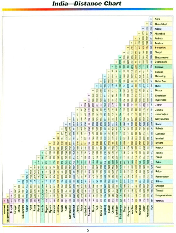
| India – Distance Chart | 05 |
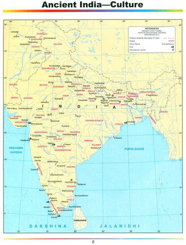
| Ancient India Cultural | 6-7 |
| India – Political Map | 08 |
| India – Facts & Figures | 09 |
| India – Physical | 10-11 |
| India – Educational Institutions | 12-13 |
| India – Soils | 14-15 |
| India – Geology | 16-17 |
| India – Land Use | 18-19 |
| India – Manufacturing industries | 20-21 |
| India – Handicrafts | 22-23 |
| India – Rainfall & Climate Regions | 24-25 |
| India – National Highways | 26-27 |
| India – Railways | 28-29 |
| India – Air & Sea Routes | 30-31 |
| India – Monuments & Holy Places | 32-33 |
| India – Scenic Places | 34-35 |
| India – Beaches | 36-37 |
| India – Wildlife & National Parks | 38-39 |
| North Zone | |
| Jammu & Kashmir | 40-42 |
| Srinagar | 43 |
| Himachal Pradesh | 44-46 |
| Shimla | 47 |
| Punjab | 48-51 |
| Haryana | 52-54 |
| Chandigarh | 55 |
| Delhi | 56-61 |
| Faridabad | 62 |
| Gurgaon | 63 |
| Noida | 64 |
| Ghaziabad | 65 |
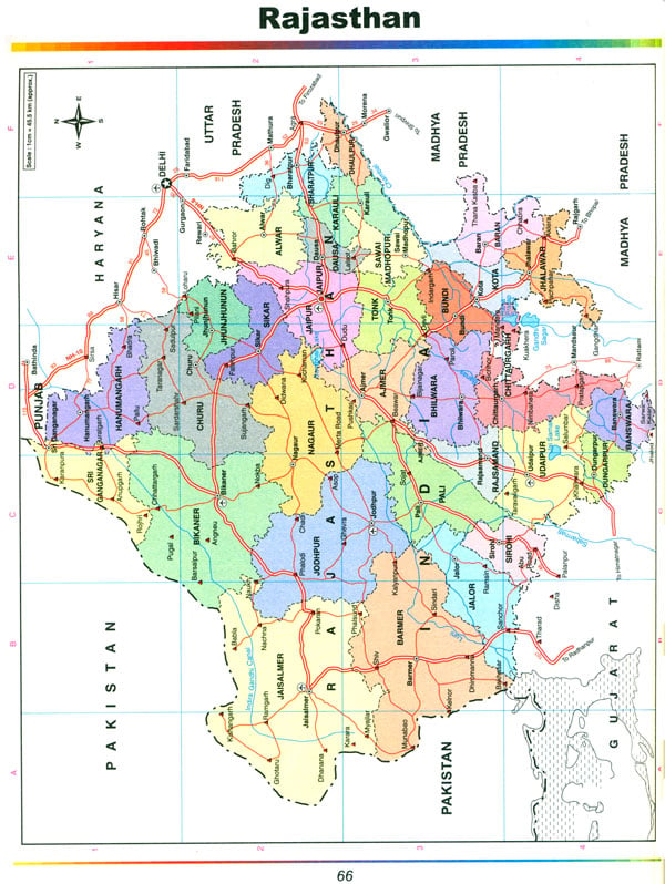
| Rajasthan | 66-70 |
| Jaipur | 71 |
| Uttaranchal | 72-76 |
| Dehra Dun | 77 |
| Uttar Pradesh | 78-81 |
| Agra | 82 |
| Varanasi | 83 |
| Lucknow | 84 |
| Kanpur | 85 |
| East Zone | |
| Bihar | 86-88 |
| Patna | 89 |
| Jharkhand | 90-91 |
| West Bengal & Sikkim | 92-95 |
| Kolkata | 96 |
| Gangtok | 97 |
| North Eastern States | 98-101 |
| Guwahati | 102 |
| Orissa | 104-106 |
| Bhubaneshwar | 107 |
| West Zone | |
| Gujarat Diu & Daman Dadra & Nagar Haveli | 108-110 |
| Ahmedabad | 111 |
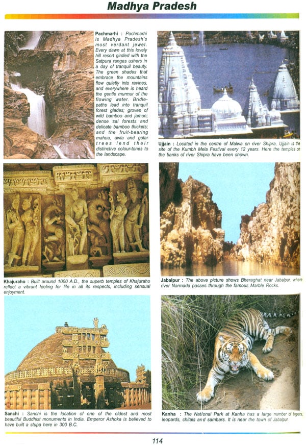
| Madhya Pradesh | 112-114 |
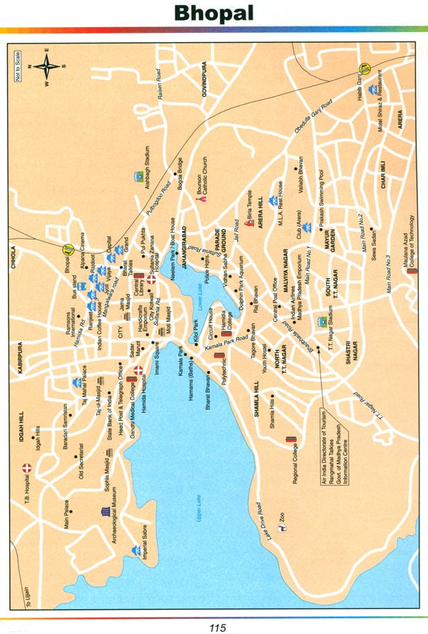
| Bhopal | 115 |
| Chhattisgarh | 116-117 |
| Maharashtra | 118-121 |
| Mumbai | 122 |
| Pune | 123 |
| Goa | 124-126 |
| Panaji | 127 |
| South Zone | |
| Karnataka | 128-132 |
| Bengaluru | 133 |
| Andhra Pradesh and Andaman & Nicobar islands | 134-136 |
| Hyderabad | 137 |
| Kerela & Lakshdweep | 138-140 |
| Thiruvananthapuram | 141 |
| Tamil Nadu & Puducherry | 142-146 |
| Chennai | 147 |
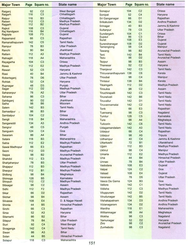
| Index | 148-151 |
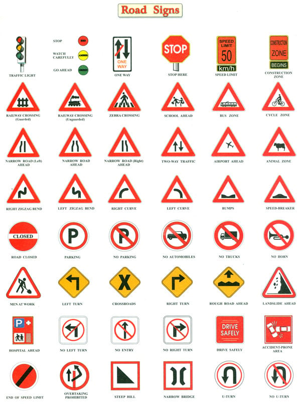
| Road Signs | 152 |
